|
|
|
Roanoke
Jefferson Street SE, Roanoke,
VA ,
USA
Latitude & Longitude:
37° 16' 3.19764",
-79° 56' 26.36232"
|
|

Virginia State
Historical Marker
|
| |
| |
(Obverse:)The first village here, at Pate's Mill and Tavern on Evans' Mill Creek, was called Big Lick for nearby salt marshes. In 1839 it was laid off as the town of Gainesborough. After the coming of the Virginia and Tennessee Railroad (later N.&W.) in 1852, another village sprang up about the old Stover House that was also named Big Lick. Gainesborough became known as Old Lick. (Reverse:) In June, 1864, General Hunter passed here retreating from Lynchburg. In 1874 Big Lick was incorporated. In 1881, with the junction of the new Shenandoah Valley Railroad with the N.&W., rapid growth began. In 1882 the name was changed to Roanoke; in 1884 it was incorporated as a city. In 1909 the Virginian Railroad operated its first train. In recent years Roanoke became the third city of Virginia.
Last updated: 2/14/2015 15:17:00 |
|
|
| |
|
|
Image Gallery
|
|
|
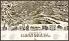
Roanoke Virginia Map
|
|
|