| |
|
|
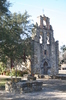
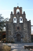
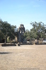
Mission San Francisco de la Espada (Mission St. Francis of the Sword) |
|
 |
|
10040 Espada Road, San Antonio,
TX,
USA
Latitude & Longitude:
29° 19' 2.298",
-98° 26' 59.1"
|
| |
| |
|
Texas State
Historical Marker |
Established in San Antonio in 1731. May have been named for statue of St. Francis in the chapel which, according to tradition, once grasped a sword. One of the few missions near which descendants of the Indian converts and Spaniards still live, Espada is considered by some to date back to the Mission San Francisco De Los Tejas, founded in East Texas in 1690. A succession of moves eventually brought it here.
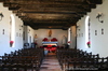
The original buildings at Espada, the farthest south of the five missions near San Antonio, were undoubtly of adobe. A wall surrounded the church (usually called a chapel), with a friary, a granary, and work shops. Extensive farms and pastures lay nearby.
By 1745 the Indians produced grain and beans, and the mission owned 1,150 head of cattle and 750 sheep.
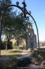
One of the few remaining early structures is the southeast Bastion (fortified round tower), which is the only mission fort left intact in San Antonio. Its three-foot rock walls, which contain holes for cannons and muskets, support a vaulted roof. Composing Espada's once-vital waterworks are a dam (one mile north), an irrigation ditch, and a fine aqueduct (near this site) the only extant Spanish aqueduct in the United States.
This page last updated: 7/15/2008 |
Image Gallery
Mission San Francisco de la Espada (Mission St. Francis of the Sword) Historical Marker Location Map, San Antonio, Texas
|
|
|
|