| |
|
|
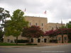
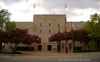
City of Temple |
|
 |
|
Temple,
TX,
USA
Latitude & Longitude:
31° 5' 50.1",
-97° 20' 29.7996"
|
| |
| |
|
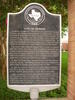
Texas State
Historical Marker |
Founded in 1881 on the Santa Fe line, Temple, like dozens of Texas towns, owed its beginning to the railroad and was, in fact, named for a Santa Fe official, B.M Temple. On June 29, 1881, a gala town lot sale, with free barbecue, was held by promoters. In 1882, the Missouri, Kansas, & Texas built through and soon after, Santa Fe made Temple a division point. For some time, however, Temple was a town of shacks and tents with the usual large number of saloons and tough characters found in the early west. Locally, it was called Tanglefoot, because some citizens found that the combination of muddy streets and liquor made walking rather difficult at times. At 1882, the town was incorporated and two private schools began. The Temple Academy was soon organized and public school was established in 1884. In 1893, the annual Temple Stag Party began, growing out of a private Thanksgiving celebration attended by the town's leading men. It was held until 1923. Today Temple is known as a major hospital center of the south, for located here are Santa Fe Hospital (founded 1891), King's Daughters Hospital (1896), the Scott and White Hospital (1904), and the Veterans Administration (formerly McCloskey) Hospital (1942). (1968)
This page last updated: 7/20/2010 14:26:16 |
Image Gallery
City of Temple Historical Marker Location Map, Texas
|
|
|
|