| |
|
|
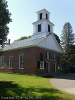
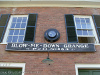
Blow-Me-Down Grange
1071 NH 12-A, Plainfield,
NH
,
USA
Latitude & Longitude:
43° 32' 0.97818",
-72° 21' 22.2939"
|
|

Listed in the National Register of Historic Places |
| |
| |
| |
|
|
Blow-Me-Down Grange was listed in the National Register of Historic Places on March 02, 2001.
| StoppingPoints.com Editorial on Blow-Me-Down Grange: | | Blow-Me-Down Grange is a Greek Revival style church building designed by Charles Egglestone and built in 1839. It is also known as the Plainfield Congregational Church and Old South Church. |
Last updated: 9/21/2011 11:05 |
|
|
| |
|
|
Image Gallery
|
|
|
Blow-Me-Down Grange Historical Marker Location Map, Plainfield, New Hampshire
|
|
|