| |
|
|
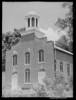
Rodney Presbyterian Church
Muddy Bayou Rd., Rodney,
MS,
USA
Latitude & Longitude:
31° 51' 45.6588",
-91° 11' 59.9172"
|
|
 |
| |
| |
| |
|
Mississippi State
Historical Marker |
Chartered in Jan. 1828, as the Presbyterian Church of Petit Gulf. Shelled by the gunboat Rattler when Federal sailors were captured by Confederate cavalry while attending Sunday services, September 13, 1863.
Last updated: 7/5/2010 9:19
| StoppingPoints.com Editorial on Rodney Presbyterian Church: | | One of the cannon balls hit the church and is embedded in the brick wall to this day. |
|
|
|
Related Themes: C.S.A., Confederate States of America, Confederacy
Explore other
Mississippi Civil War Historical Markers.
|
| |
|
|
Image Gallery
|
|
|
Rodney Presbyterian Church Mississippi
|
|
|