| |
|
|
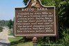
Bayou Sara
Hwy 10, St. Francisville,
LA,
USA
Latitude & Longitude:
30° 47' 5.8812",
-91° 22' 47.8596"
|
|

Louisiana State
Historical Marker |
| |
| |
| |
|
|
Founded by John Mills in 1790 as a trading post and cotton port. Bayou Sara was the river port for the Felicianas and was one of the largest shipping ports between Natchez and New Orleans before 1860.
Last updated: 3/27/2016 10:59
| StoppingPoints.com Editorial on Bayou Sara: | | Called New Valencia by the Spanish, was one of the earliest towns in Florida parishes. Bayou Sara was the river port for the Felicianas and was one of the largest shipping points between Natchez and New Orleans before 1860. |
|
|
|
|
| |
|
|
Image Gallery
|
|
|
Bayou Sara Historical Marker Location Map, St. Francisville, Louisiana
|
|
|