| |
|
|
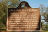
Allard Plantation
City Park Ave and Carrollton Ave, New Orleans,
LA,
USA
Latitude & Longitude:
29° 58' 58.7928",
-90° 5' 28.9392"
|
|

Louisiana State
Historical Marker |
| |
| |
| |
|
|
Plantation of Louis Allard was purchased by his grandfather, Don Santiago Lorreins in 1770's from estate of Francisco Hery, called Duplanty, builder of the first Cabildo Building in 1769. Acquired from Allard in 1845 by J. McDonough — given to New Orleans in 1850.
Last updated: 3/13/2016 18:41 |
|
|
|
| |
|
|
Image Gallery
|
|
|
Allard Plantation Historical Marker Location Map, New Orleans, Louisiana
|
|
|