| |
|
|
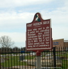
Port Hudson Siege
Hwy 64 and Hwy 964, Port Hudson,
LA,
USA
Latitude & Longitude:
30° 39' 17.0424",
-91° 11' 35.9124"
|
|

Louisiana State
Historical Marker |
| |
| |
| |
|
|
Seven miles west is site of anchor fort controlling Mississippi. Here 6500 Confederates held 30,000 Union troops May 21 until July 8, 1863. Fall of Port Hudson opened river, hastening fall of Confederacy.
Last updated: 3/14/2016 18:54 |
|
|
Related Themes: C.S.A., Confederate States of America, Confederacy
Explore other
Louisiana Civil War Historical Markers.
|
| |
|
|
Image Gallery
|
|
|
Port Hudson Siege Louisiana
|
|
|