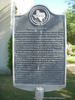
Created and organized in 1846. Named for pioneer resident Andrew Jackson Titus (1814-1855), who opened county's first road, to river port in Jefferson. Until after the Civil War, Titus County also included areas of present-day Franklin and Morris counties. Six mail routes going by horseback, had pack mules to follow lead horse. High waters in creeks and Sulphur River often halted travel. Record time to haul cotton to Jefferson was 5 days by ox wagon. In 1860 had 9,648 people. Voted 411 to 275 in favor of secession. Sent 10 military companies to Civil War. While home tables drew heavily on game foods (deer, wild turkeys, pigeons, bear), county furnished Confederate commissary with beef, butter, corn, rice, cotton, oats, sweet potatoes, flour, cornmeal, leather, lumber, pottery, tobacco, whiskey and wool. Wartime manufacturing plants included 9 sawmills, 8 gristmills, tanneries and a steam powered distillery. Mount Pleasant had a Confederate transportation depot employing blacksmiths, carpenters, harness makers, wheelwrights. It procured equipment and horses and mules, and made gear, harness and wagons for the purpose of moving men, army supplies and government owned cotton.
This page last updated: 6/28/2010 17:30:12 |
Image Gallery
Titus County C. S. A. Historical Marker Location Map, Texas
|
|
Related Themes: Texas C.S.A., Texas Confederate States of America, Confederacy
Explore other
Texas Confederate Historical Markers.
|