| |
|
|
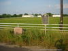
Site of Camino Real |
|
 |
|
Caldwell,
TX,
USA
Latitude & Longitude:
30° 24' 51.293988",
-96° 48' 45.248148"
|
| |
| |
|
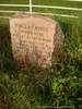
Texas State
Historical Marker |
(The old San Antonio Road) Great thoroughfare of early Texas. Following ancient Indian and buffalo paths, sometimes on same course as 1691 Trail of the Padres, stretches 1,000 miles from Saltillo, Mexico, to present Louisiana. Highway for explorers, traders, smugglers, adventurers, settlers, armies. Was surveyed about 1800 and given name of King's Highway. Here, as in some other areas, the modern highway follows historic El Camino Real. Also, in this particular area, El Camino Real marked boundary between the major early 19th century colonies of Stephen F. Austin and Sterling C. Robertson. (1968)
This page last updated: 7/15/2008 |
Image Gallery
Site of Camino Real Historical Marker Location Map, Caldwell, Texas
|
|
|
|