| |
|
|
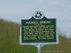
Hamill Spring
Antioch Rd, Louisville,
MS,
USA
Latitude & Longitude:
33° 14' 20.8104",
-88° 58' 39.828"
|
|
 |
| |
| |
| |
|
Mississippi State
Historical Marker |
Spring and small holding reservoir, which lie two miles north, were used during droughts as a water source for settlers between the early 1800s and 1930s. Also used to feed boilers for nearby Gus Boyd Sawmill. Spring named for Robert Hamill, an early settler.
Last updated: 6/17/2009 10:15:00 |
|
|
|
| |
|
|
Image Gallery
|
|
|
Hamill Spring Historical Marker Location Map, Louisville, Mississippi
|
|
|