| |
|
|
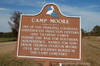
Camp Moore
Hwy 51, Tangipahoa,
LA,
USA
Latitude & Longitude:
30° 36' 57.1428",
-90° 29' 42.2124"
|
|

Louisiana State
Historical Marker

Listed in the National Register of Historic Places |
| |
| |
| |
|
|
One of the principal Louisiana Confederate induction centers and training camps during the War for Southern Independence. Named for Governor Thomas Overton Moore. Over 400 soldiers buried in the camp cemetery.
Last updated: 4/10/2016 09:20:00
| StoppingPoints.com Editorial on Camp Moore: | | (A Civil War marker.) |
|
|
|
Related Themes: C.S.A., Confederate States of America, Confederacy
Explore other
Louisiana Civil War Historical Markers.
|
| |
|
|
Image Gallery
|
|
|
Camp Moore Historical Marker Location Map, Tangipahoa, Louisiana
|
|
|