| |
|
|
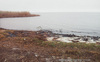
Lake Pontchartrain
Lakeshore Ave and St. Bernard Ave, New Orleans,
LA,
USA
Latitude & Longitude:
30° 1' 37.0344",
-90° 4' 46.488"
|
|

Louisiana State
Historical Marker |
| |
| |
| |
|
|
Traveled on by Iberville, 1699 and named for the French Minister of Marine. Indians called it Okwa-ta, wide water. First port of embarkation was at the site where Bayou St. John flows from this lake. It was the first water travel route to the City of New Orleans.
Last updated: 8/10/2010 16:01 |
|
|
|
| |
|
|
Image Gallery
|
|
|
Lake Pontchartrain Historical Marker Location Map, New Orleans, Louisiana
|
|
|