| |
|
|
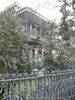
Garden District
Washington and Prytania, New Orleans,
LA,
USA
Latitude & Longitude:
29° 55' 46.9848",
-90° 5' 6.2844"
|
|

Louisiana State
Historical Marker

Listed in the National Register of Historic Places |
| |
| |
| |
|
|
Famous for 19th century homes and gardens, area originally part of Livaudais Plantation. Became part of City of Lafayette, 1833. Annexed by Orleans, 1852. Designated National Historic Landmark, 1974.
Last updated: 8/10/2010 15:57 |
|
|
|
| |
|
|
Image Gallery
|
|
|
Garden District Historical Marker Location Map, New Orleans, Louisiana
|
|
|