| |
|
|
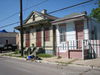
Faubourg Treme
Esplanade Ave, New Orleans,
LA,
USA
Latitude & Longitude:
29° 58' 21.3132",
-90° 4' 23.322"
|
|

Louisiana State
Historical Marker |
| |
| |
| |
|
|
Located on a portion of the Morand-Moreau plantation and sold by Claude Tremé in 1810 to the city of New Orleans, it became the city's first subdivision and is considered to be America's oldest existing African American neighborhood. It was home to a diverse mix of residents including free people of color and Europeans that prospered as craftsmen, artists, musicians, entrepreneurs, doctors and teachers. Historical sites within Tremé include Louis Armstrong Park, Congo Square, and St. Augustine Church. Historic Tremé Cultural Alliance
Last updated: 3/13/2016 17:23 |
|
|
|
| |
|
|
Image Gallery
|
|
|
Faubourg Treme Historical Marker Location Map, New Orleans, Louisiana
|
|
|