|
|
|
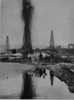
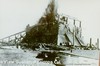
Lakeview Gusher 1
Petroleum Club Rd (County Rd 277T, P.M. 1.1) between Kerto and Cadet Rds, 1.5 mi N of Maricopa via Hwy 33, Maricopa,
CA ,
USA
Latitude & Longitude:
35° 5' 29.1264",
-119° 24' 4.9572"
|
|

California State
Historical Marker
|
| |
| |
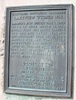
America's most spectacular gusher 'blew in' here on March 14, 1910. Initial flow was 18,000 barrels per day, and later reached an uncontrolled peak of 100,000 barrels per day, completely destroying the derrick. This Union Oil Company well between Taft and Maricopa produced nine million barrels of oil in 18 months.
Dedicated Feb. 3, 1952
Marker placed by Miocene Parlor No. 228 N.D.G.W.
Kern County Historical Society
Kern County Museum
State Registered Landmark No. 485
Last updated: 2/15/2016 21:05:00 |
|
|
| |
|
Related Themes: C.S.A., Confederate States of America, Confederacy, Union States
Explore other
California Civil War Historical Markers.
|
Image Gallery
|
|
|
Lakeview Gusher 1 Historical Marker Location Map, Maricopa, California Map
|
|
|