| |
|
|
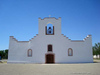
Socorro Mission La Purisima |
|
 |
|
Socorro,
TX,
USA
Latitude & Longitude:
31° 39' 32.155632",
-106° 18' 6.83064"
|
| |
| |
|
Texas State
Historical Marker |
During the pueblo revolt of 1680, Gov. Don Antonio de Otermin and Father Francisco de Ayeta led Piro Indian and Spanish refugees out of New Mexico into this region, establishing a settlement they named Socorro after the home they had left. The town's first permanent adobe church was built in 1691 and was called Nuestra Senora de la Limpia Concepcion de Los Piros Del Socorro (Our Lady of the Immaculate Conception of the Piros of Socorro). Construction of the present structure began following a destructive 1829 flood and was completed in 1840. The flood changed the course of the Rio Grande from north of Socorro to south of the townsite. When the river was declared the U.S. - Mexico boundary, Socorro became part of the United States. Under the administration of Franciscan Monks for 172 years, the church was later governed by Diocesan priests as well as by Italian and Mexican Jesuits. Its history spans the time of the region's occupancy by Spain, Mexico, and the United States. Although Socorro Mission La Purisima, as it is now known, has been overshadowed by urban growth in nearby El Paso, it remains one of the oldest continuously occupied settlements in the southwest. (1983)
This page last updated: 11/3/2010 12:36:07 |
Image Gallery
Socorro Mission La Purisima Historical Marker Location Map, Texas
|
|
|
|