| |
|
|
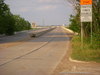
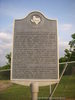
Shady Grove Road Bridge |
|
 |
|
E. of Intersection of Shady Grove Rd. & Irving Blvd., Irving,
TX,
USA
Latitude & Longitude:
32° 48' 7.26624",
-96° 54' 38.154096"
|
| |
| |
|
Texas State
Historical Marker |
The Trinity River has played an important part in the history of Dallas County. Early navigation projects were instrumental in the area's economic development. Heavy rains often caused the river to overflow its banks and after a disastrous flood in 198 area officials began flood control planning. By 1930 the Dallas Levee Improvement District completed a project which modified the river's channels and reclaimed about 10,000 acres of land. The Shady Grove Road Bridge was built at this site in 1931. The main span was a Parker pony truss design and the bridge extended 1,778 feet in length. It connected southeast Irving to the new industrial district of west Dallas, thereby contributing significantly to the growth and development of the city of Irving. By 1984, when it was closed for safety considerations, the bridge was providing access to more than 14,000 vehicles per day. In 1990, through a joint effort of Dallas County, the State Department of Highways and Public Transportation, and the Federal Highway Administration, a new bridge was completed at the same site, replacing the 1931 structure. This continues to serve as a major traffic artery between Irving and Dallas.
This page last updated: 7/15/2008 |
Image Gallery
Shady Grove Road Bridge Historical Marker Location Map, Irving, Texas
|
|
|
|