| |
|
|
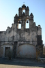
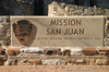
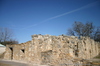
Mission San Juan Capistrano |
|
 |
|
9101 Graf Road, San Antonio,
TX,
USA
Latitude & Longitude:
29° 19' 57.0756",
-98° 27' 18.0324"
|
| |
| |
|
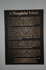
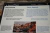
Texas State
Historical Marker |
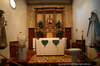
Founded in March, 1731, by Franciscan Missionaries on the banks of the San Antonio River; Named for St. John of Capistrano, who in 1456 lead a European religious crusade that saved the city of Belgrade from infidels. Mission San Juan was a succesor to Mission San Jose De Los Nazonis, established in 1716 in East Texas. It moved here due to the difficulty of defense. One of a complex of missions, San Juan was dovoted to the cultural and religious conversion of the Coahuiltecan-speaking indians of South Texas.
During the uncertain early years, buildings were constructed, crops planted, and the Indians had to be continually persuaded to stay long enough to reap the benefits of civilizaton.
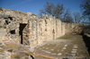
Apache raids, cholera and smallpox epidemics, and harassment by the Civil authorities also plagued the missions constantly. By 1762, however, San Juan had surplus harvests of corn, cotton, beans, chili peppers, watermelons,and cantaloupes. It also owned numerous cattle, sheep, goats, and horses. The 203 resident indians lived in thatched huts; the chapel and convent were of stone.
The mission was secularized in 1794. In 1967, when the buildings were restored, many artifacts relating to the three centuries of occupancy were unearthed.
This page last updated: 7/15/2008 |
Image Gallery
Mission San Juan Capistrano Historical Marker Location Map, San Antonio, Texas
|
|
|
|