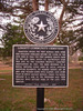
Tradition holds the first burials here were for enslaved Africans before the close of the Civil War in 1865; The first marked graves date to the late 1860s. When J.C. McCrocklin sold this site to the Colored People's Cemetery Association in 1907, the deed referred to a burial ground long used by local African American residents. Six marked graves are of men and women born into slavery, and more than 20 show military service. Today, the burial ground is a link to the freedmen and their families who settled here in the late 19th century. Historic Texas Cemetery - 2004.
This page last updated: 7/15/2008 |
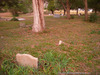
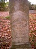
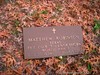
Image Gallery
Liberty Community Cemetery Historical Marker Location Map, Independence, Texas
|
|
Related Themes: Texas C.S.A., Texas Confederate States of America, Confederacy, Texas Cemetery Markers, Cemeteries, Texan Graveyards,
Burial Grounds and Graves
Explore other historical Texas Cemeteries.
View other Texas Confederate Historical Markers
|