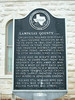
Organized 1856; had 1028 people in 1860; favored secession by 85 to 75 vote in 1861. Sent 2 units to serve in Texas State Troops, 2nd Frontier District; one unit to 17th Texas Infantry; 2 units to 27th Brigade, Texas Militia. Also had 48 Minute Men in 6 patrols to guard home front and property of men away at war. After a week of duty, each unit returned home to aid women and children tending cattle, crops. Helped supply frontier troops and miners in Longhorn Caverns. Indians still roamed here during Civil War, stealing horses, killing hunters and others.
This page last updated: 7/15/2008 |
Image Gallery
Lampasas County, C.S.A. Historical Marker Location Map, Texas
|
|
Related Themes: Texas C.S.A., Texas Confederate States of America, Confederacy
Explore other
Texas Confederate Historical Markers.
|