| |
|
|
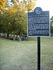
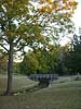
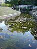
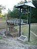
Grapevine Springs Park |
|
 |
|
700 S Park Rd, Coppell,
TX,
USA
Latitude & Longitude:
32° 57' 16.768872",
-97° 0' 3.342132"
|
| |
| |
|
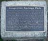
Texas State
Historical Marker |
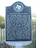
The Grapevine Springs, which flow into the Elm Fork of the Trinity River, have attracted visitors for more than 2,000 years. In 1843, the Republic of Texas President, Sam Houston, camped here during treaty negotiations with Native Americans. The treaty was later signed at Bird's Fort.
Â
In 1936, Dallas County accepted the donation of Houston's camp site as park land, and the Federal Works Progress Administration (W.P.A.) built rock walls, picknick facilities, footbridges, & other features.
Â
During WWII, ownership of the parcel of land reverted back to previous owners.
Â
Later, the Baptist Foundation of Texas got the land and donated it to Dallas County in 1991.
Â
Today, the City of Coppell maintains Grapevine Springs Park, and efforts to restore its WPA features are ongoing.
This page last updated: 7/4/2010 19:32:18
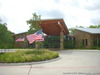
| StoppingPoints.com Editorial on Grapevine Springs Park: | 2010: Coppell has now opened a Senior and Community Center adjacent to the Grapevine Springs park:
Coppell Senior and Community Center
345 W. Bethel Road
Coppell, TX 75019
Phone: (972) 462-5136 |
|
Image Gallery
Grapevine Springs Park Historical Marker Location Map, Coppell, Texas
|
|
|
|