| |
|
|
Franklin |
|
 |
|
Hwy. 79 and FM 46, Franklin,
TX,
USA
Latitude & Longitude:
31° 1' 31.14572999988",
-96° 29' 10.37676000012"
|
| |
| |
|
Texas State
Historical Marker |
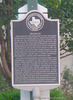
This community was established in 1872 and named Morgan for a railroad official. Located on the right-of-way of the International Railway Company, the town contained a depot and three stores in its first year. By 1879, the town had 200 residents and voters transferred the county seat from Calvert to Morgan. The community applied for a post office in 1880. Another Texas post office was named Morgan, so the town name was changed to Franklin after the name of the original county seat. A stone courthouse, designed by R. E. Ruffini, was completed in 1882. The town's first newspaper, the Franklin Weekly, was published by J. A. Keigewin. By 1885, Franklin had three hotels, three churches, and two gristmills. Mineral springs attracted visitors to the area for many years. A cemetery was formally established in 1880 at a site where several graves were already in existence. The community's first school building, a frame structure, burned in 1894 and another was erected. The First National Bank of Franklin was chartered in 1905; the First State Bank was established in 1913. A Carnegie Library was built and equipped with an auditorium. By the 1970s Franklin, an incorporated community, had a mayor-council form of city government. (1997)
This page last updated: 7/15/2008 |
Image Gallery
Franklin Historical Marker Location Map, Texas
|
|
|
|