| |
|
|
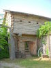
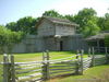
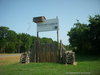
Fort Parker |
|
 |
|
Of FM 1245, in Fort Parker Historical Park, Groesbeck,
TX,
USA
Latitude & Longitude:
31° 33' 49.8528",
-96° 32' 52.7496"
|
| |
| |
|
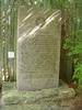
Texas State
Historical Marker |
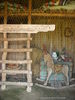
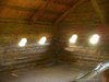
Built 1834 for protection from Indians. Named for leaders who bought first Predestinarian Baptist church body to Texas: Elder Daniel Parker; his father, Elder John; brothers Jas. W., Benjamin, Silas, John. Also here were Kellogg, Frost, Nixon, Duty and Plummer families on May 18, 1836, raiding Comanches killed Benjamin, John and Silas Parker, Samuel and Robert Frost and others; captured Elizabeth Kellogg, Rachel Plummer and son James, and Sila's children, John and Cynthia Ann in captivity, Cynthia Ann married Chief Peta Nacona; her son, Quanah, was last Comanche Chief. With her baby, Prairie Flower, in 1860 she was captured by Texas Rangers. She, the baby and Quanah are buried at Fort Sill.
This page last updated: 8/8/2010 23:09:14
| StoppingPoints.com Editorial on Fort Parker: | | Old Fort Parker is now being restored by private citizens. The Old Fort Parker may be found near the Fort Parker State Park: 866 Park Road 35, Groesbeck, TX 76642. Website: www.oldfortparker.com |
|
Image Gallery
Fort Parker Historical Marker Location Map, Groesbeck, Texas
|
|
Related Themes: Texas C.S.A., Texas Confederate States of America, Confederacy
Explore other
Texas Confederate Historical Markers.
|
|