| |
|
|
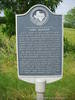
Fort Oldham |
|
 |
|
Cooks Point,
TX,
USA
Latitude & Longitude:
30° 33' 59.694624",
-96° 35' 15.1197"
|
| |
| |
|
Texas State
Historical Marker |
Built 1836-37 by pioneers who took refuge with William Oldham (1798?-1868), Infantry major in Texas War for Independence. The fort stabilized the area, as dozens lived there in seasons of Indian raids, and eventually preachers who helped found early church. By 1838, Fort Oldham had a post office and was a stopping place on Independence-Tenoxtitlan Road. Maj. Oldham joined Somervell and Mier Expeditions (1842) to counter Mexican raids into Texas. Captured by the foe, he escaped, fought way through perils, and returned home. He amassed fortune in land surrounding fort site.
This page last updated: 7/15/2008 |
Image Gallery
Fort Oldham Historical Marker Location Map, Cooks Point, Texas
|
|
|
|