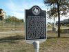
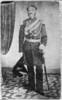
Fort Magruder, C.S.A. During the Civil War, Fort Magruder was built near here west of Congress Avenue. Named for Gen. John Bankhead Magruder, commander of Texas Confederate forces, it was one of three forts planned to protect Austin from a possible Union attack from the coast. In the winter of 1863-64, Maj. Julius Kellersberg supervised building of the L-shaped earthen fort. Due to wartime manpower shortages, citizens provided slaves to construct the fort. Large enough for 200 soldiers, the fort was sited along what was then the San Antonio Road. Other forts were planned for the Houston Road and College Hill. In early 1864, Union forces attacked Texas from the Red River area of Louisiana, and Fort Magruder was abandoned.
This page last updated: 6/14/2016 00:54:24
| StoppingPoints.com Editorial on Fort Magruder, C.S.A.: | | Also see the Fort Magruder located in Virginia which is also named after Gen. John Magruder. |
|
Image Gallery
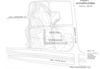
Fort Magruder, C.S.A. Historical Marker Location Map, Austin, Texas
|
|
Related Themes: Texas C.S.A., Texas Confederate States of America, Confederacy
Explore other
Texas Confederate Historical Markers.
|