| |
|
|
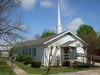
Bethel Community |
|
 |
|
Flower Mound,
TX,
USA
Latitude & Longitude:
33° 3' 41.0652",
-97° 3' 40.8024"
|
| |
| |
|
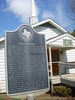
Texas State
Historical Marker |
Settlement of this area began in the 1850s. Among the pioneer families were those of Samuel K. Smith, Anderson Nowlin, William Crawford, and Sam Lusk. As family farms were established, a loosely organized rural community was formed. By the 1870s more people had moved to the area, including the F. M. Frie family. The Frie and Nowlin families both set aside land for school and church purposes. A one-room schoolhouse built on the Nowlin land about 1871 became known as Frie School. It also served as a Union church and community center. A church building was erected on Frie land in 1882. After Bethel Presbyterian Church was organized in 1883, the school and community took the Bethel name. At its height in the early 20th century, Bethel community included about one hundred families. After it was bypassed by the railroad in 1875, Bethel began to decline in favor of Lewisville. The Bethel School consolidated with the Lewisville School system in 1940, and the area once encompassed by farms of the Bethel Community eventually became parts of several towns, including Flower Mound, Lewisville, Highland Village, and Copper Canyon. (1990)
This page last updated: 7/15/2008
| StoppingPoints.com Editorial on Bethel Community: | | See also the Bethel Cemetery in nearby Coppell for more info about the Bethel Community. |
|
Image Gallery
Bethel Community Historical Marker Location Map, Flower Mound, Texas
|
|
|
|