| |
|
|
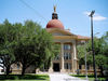
Bee County |
|
 |
|
2 mi.N on US 181, Pettus,
TX,
USA
Latitude & Longitude:
28° 24' 5.04",
-97° 44' 53.88"
|
| |
| |
|
Texas State
Historical Marker |
Named for Col. Barnard E. Bee (1787-1853), who served Republic of Texas as Secretary of War, Secretary of State, and Minister to the United States. County was created by legislative act on Dec. 8, 1857; organized Jan. 25, 1858, from land earlier in Goliad, Karnes, Live Oak, Refugio, and San Patricio counties. County seat in 1858 was on Medio Creek; since 1860 at present Beeville. A cattle region since Spanish times, Bee County became important beef producer in 1865. San Antonio and Aransas Pass Railroad provided first modern transportation in 1886. Oil was discovered here in 1929.
This page last updated: 7/15/2008 |
Image Gallery
Bee County Historical Marker Location Map, Texas
|
|
|
|