| |
|
|
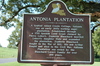
Antonia Plantation
River Rd., Brusly,
LA,
USA
Latitude & Longitude:
30° 22' 30.5166",
-91° 14' 33.61308"
|
|

Louisiana State
Historical Marker |
| |
| |
| |
|
|
A typical raised creole cottage, Antonia was an early 1800's working sugar plantation. Established through a 1793 Spanish Land Grant claimed by Pierre Lebert. Zephirin Blanchard married Lebert's daughter Elsie and expanded the plantation. Zephirin Blanchard fought in the War of 1812. His son Arthur fought and died in the Civil War. Antonia Plantation was owned by the Blanchard - Levert family for over 200 years.
Erected by the Becnel Family 2008.
Last updated: 3/13/2016 19:50 |
|
|
Related Themes: C.S.A., Confederate States of America, Confederacy
Explore other
Louisiana Civil War Historical Markers.
|
| |
|
|
Image Gallery
|
|
|
Antonia Plantation Historical Marker Location Map, Brusly, Louisiana
|
|
|