| |
|
|
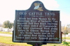
Old Cattle Trail
Hwy 20, Chachahoula,
LA,
USA
Latitude & Longitude:
29° 42' 16.452",
-90° 54' 32.6196"
|
|

Louisiana State
Historical Marker |
| |
| |
| |
|
|
Route led from Mexico to the Mississippi River at Vacherie. One segment, Bull Run Road, starting at Central, ended at Chachahoula. The trail continued West along ridges to Gibson, Morgan City, the Teche lands on to the Camino Real during latter French and early Spanish period.
Last updated: 3/13/2016 18:14 |
|
|
|
| |
|
|
Image Gallery
|
|
|
Old Cattle Trail Historical Marker Location Map, Chachahoula, Louisiana
|
|
|