| |
|
|
La Butte
Highway 56, Cocdrie,
LA,
USA
Latitude & Longitude:
29° 20' 10.4964",
-90° 38' 24.5004"
|
|

Louisiana State
Historical Marker |
| |
| |
| |
|
|
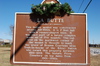
This Indian mound was constructed around AD 1000. It is 7 feet tall with a square~shaped base. It was once part of a larger complex made up of up to five mounds. The oak tree on the northwest corner is thought to mark the grave of Houma Courteau alias Touh~la~bayne of the Biloxi Nation who owned this property between 1822~1844. The historic Picou Cemetery on top dated from 1901~1990's.
Last updated: 4/15/2016 17:37:17 |
|
|
|
| |
|
|
Image Gallery
|
|
|
La Butte Historical Marker Location Map, Cocdrie, Louisiana
|
|
|