| |
|
|
Thirty-First Parallel
Tangipahoa,
LA,
USA
Latitude & Longitude:
30° 52' 29.4816",
-90° 30' 41.8824"
|
|

Louisiana State
Historical Marker |
| |
| |
| |
|
|
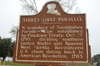
North boundary of Tangipahoa Parish. Line established by Pinckney Treaty, Oct. 27, 1795, dividing southern United States and Spanish West Florida. Recognized U.S. claim dating back to American Revolution, 1783.
Last updated: 3/13/2016 19:40
| StoppingPoints.com Editorial on Thirty-First Parallel: | | 31st Parallel marker denotes the northern boundary of the parish, a line established by the Pinckney Treaty in 1795. |
|
|
|
|
| |
|
|
Image Gallery
|
|
|
Thirty-First Parallel Historical Marker Location Map, Tangipahoa, Louisiana
|
|
|