| |
|
|
Pass Manchac
Manchac,
LA,
USA
Latitude & Longitude:
30° 19' 4.3824",
-91° 3' 52.5168"
|
|

Louisiana State
Historical Marker |
| |
| |
| |
|
|
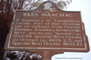
South boundary of Tangipahoa Parish. Part of line dividing Isle of Orleans from Florida Parishes. Boundary between British West Florida and Spanish Louisiana, 1763-1783; Spanish West Florida and French Louisiana., 1803; U.S. and Spanish West Florida, 1803-1810.
Last updated: 3/13/2016 19:45
| StoppingPoints.com Editorial on Pass Manchac: | | Pass Manchac served as the boundary dividing the Isle of Orleans and the Florida Parishes; between British West Florida and Spanish Louisiana; between Spanish West Florida and French Louisiana, and, between the U.S. and Spanish West Florida. |
|
|
|
|
| |
|
|
Image Gallery
|
|
|
Pass Manchac Louisiana
|
|
|