| |
|
|
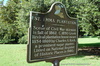
St. Emma Plantation
Hwy 1, Donaldsonville,
LA,
USA
Latitude & Longitude:
30° 4' 23.3616",
-91° 1' 36.5736"
|
|

Louisiana State
Historical Marker |
| |
| |
| |
|
|
Scene of Civil War skirmish in fall of 1862. C 1850 Greek Revival plantation house owned 1854-1869 by Charles A. Kock, a prominent sugar planter. Listed on National Register of Historic Places in 1980.
Last updated: 4/1/2016 12:55 |
|
|
Related Themes: C.S.A., Confederate States of America, Confederacy
Explore other
Louisiana Civil War Historical Markers.
|
| |
|
|
Image Gallery
|
|
|
St. Emma Plantation Historical Marker Location Map, Donaldsonville, Louisiana
|
|
|