Kaskaskia Historical Marker
Kaskaskia,
IL,
USA
Latitude & Longitude:
37° 58' 34.619988",
-89° 52' 48.54"
From 1703 until it was washed away by the Mississippi two centuries later, The ancient town of Kaskaskia-the second settlement in Illinois, the territorial capital and the first state capital- stood two miles southwest of here. Fort Kaskaskia State Park and the Menard Home are memorial to this once prominent village.
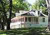
Kaskaskia Historic Homes & Houses Home of Pierre MenardThis home was built about 1800 by Pierre Menard (1766-1844), presiding officer of the Illinois Territorial Legislature and first Lieutenant Governor. ... [click for more]
Kaskaskia General Interest Kaskaskia City Historical MarkerFrom 1703 until it was washed away by the Mississippi two centuries later, The ancient town of Kaskaskia-the second settlement in Illinois, the territ... [click for more]
|