| |
|
|
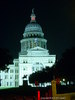
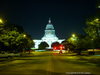
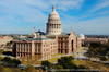
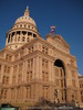
The Texas Capitol |
|
 |
|
Austin,
TX,
USA
Latitude & Longitude:
30° 16' 25.6512",
-97° 44' 27.6108"
|
| |
| |
|
Texas State
Historical Marker |
Austin became the capital of Texas Jan. 19, 1840, and this hill was platted as Capitol Square. A modest statehouse built here in the 1850s soon developed structural flaws. The Constitutional Convention of 1876 set aside 3,000,000 acres of public land to finance another building. This was authorized after the 1850s capitol burned on Nov. 9, 1881. Architect E.E. Myers of Detroit won a national competition with his plans for this capitol. The contractor was Mattheas Schnell of Rock Island, Ill. Basement excavation began early in 1882. Railroads built especially for this project hauled limestone from the Oatmanville quarries in Travis County as well as stone donated by the owners of the Granite Mountain in Burnet County. The 900 workmen on the project included 86 granite cutters brought from Scotland. Charles B. and John V. Farwell, Chicago bankers, funded the construction and were repaid in land in ten Panhandle counties, on which they founded the famous XIT Ranch. At dedication ceremonies on May 18, 1888, the capitol was accepted on behalf of the people by state senator Temple Houston, son of Texas hero Sam Houston. He called it a structure that shall stand as a sentinel of eternity. (1976)
This page last updated: 7/22/2010 19:55:55 |
Image Gallery
The Texas Capitol Historical Marker Location Map, Austin, Texas
|
|
|
|