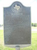
Distribution of land in the Peters Colony of North Texas triggered a dispute known as the Hedgcoxe War. The Texas Emigration and Land Co. organized the colony under an 1841 Republic of Texas law which allowed it to keep one-half of a settler's grant. After protests, this right was repealed, but in Feb. 1852 the company was compensated with 1,088,000 acres of vacant land within the colony. This action angered settlers and speculators with land certificates, who feared that the large grant would lower land values. At that time, the company's unpopular agent, English-born Henry O. Hedgcoxe, operated a land office on nearby Office Creek. On July 12 and 13, 1852, a group of Dallas men broke in and examined the land records. They reported to a meeting in Dallas on July 15 that the company was defrauding the colonists. John J. Good (1827-82), later mayor of Dallas, then led a band of armed men to Hedgcoxe's office. Hedgcoxe escaped, but most of his files were seized and the office burned. After the raid, tensions quickly cooled. The law was amended so that settlers obtained their grants from the state rather than from the company agent. The company kept its land grant, however, and Hedgcoxe returned to help survey the tract. (1975)
This page last updated: 7/15/2008 |
Image Gallery
The Hedgcoxe War Historical Marker Location Map, The Colony, Texas
|
|
Related Themes:
Peters Colony
|