| |
|
|
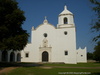
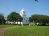
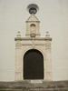
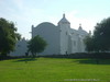
Mission Nuestra Senora del Espiritu Santo de Zuniga |
|
 |
|
Goliad,
TX,
USA
Latitude & Longitude:
28° 39' 22.10644000008",
-97° 23' 13.66215"
|
| |
| |
|
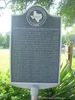
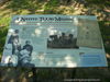
Texas State
Historical Marker |
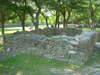
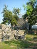
(Mission of Our Lady of the Holy Spirit of Zuniga) Founded in 1722 by the Aguayo Expedition on La Bahia del Espiritu Santo (the Bay of the Holy Spirit), present Lavaca Bay. This mission reflects its former site in the popular name, La Bahia. Its formal name (in part) honored Baltasar de Zuniga, Viceroy of New Spain. Because of threats from the French and the Indians, Spain founded this mission and its auxiliary fort, Presidio Nuestra Senora de Loreto de la Bahia (now 1/4 mi. SE) to defend its territory and convert the natives. Difficulties, however, caused both to be moved, in only four years, to the Guadalupe River, and again in 1749 to this site, on the San Antonio River. At its peak of success the mission possessed huge herds of cattle and supplied settlements in Mexico, as well as missions in present Texas. In 1758 about 180 persons resided at the mission and fort. All about were Indian jacales, crude clay-plastered brush huts thatched with grass. Spacious grazing lands and fertile fields surrounded the area, where colonists had formed a small community. After a general decline caused the mission to be secularized in 1830, it fell into ruin. In 1932, this land was deeded to the state by Goliad County. The mission complex was partially restored, 1936 - 1939. Recorded Texas Historic Landmark--1969
This page last updated: 5/31/2010 16:59:44 |
Image Gallery
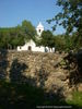
Mission Nuestra Senora del Espiritu Santo de Zuniga Historical Marker Location Map, Goliad, Texas
|
|
|
|