Historical Markers StoppingPoints.com Historical Markers, Sightseeing & Points of Interest Scenic Roads & Points of Interest
About Us | Photo Gallery | Free Widgets | Featured States | Search Site
HomeMississippi CountiesWarren County Historical Markers → Vicksburg
 

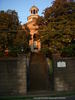
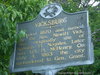
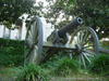
Vicksburg City Historical Markers

Map of Mississippi State Historical Marker Locations in the City of Vicksburg
 

City of Vicksburg Historical Markers

Vicksburg Historical Marker

1008 Cherry St., Vicksburg, MS, USA

Latitude & Longitude: 32° 21' 7.8444", -90° 52' 43.2228"

Founded 1820 and named for the Rev. Newitt Vick. Was originally site of Spanish Ft. Nogales. Later was U.S. Ft. McHenry. On July 4, 1863 the city surrendered to Gen. Grant.
 
StoppingPoints.com Editorial on Vicksburg:
For more info visit the Old Courthouse Museum in Vicksburg.

On the Old Courthouse Square
Image Gallery

Vicksburg Churches
Antioch Baptist Church
Bethel A.M.E. Church
Christ Episcopal Church
Vicksburg Historical Markers
901, 905, 913 Crawford Street
Anchuca
Anshe Chesed Congregation
Chickasaw Bayou Battle
Fort Nogales
Linden Plantation
Mississippi The Magnolia state (Warren)
Mississipppi Dental Association
Old Natchez District (Warren)
Pemberton Headquarters
Planter’s Hall
South Central Bell
Tobias Gibson
U.S. Marine Hospital
Vick Graves
Vicksburg Siege
Vicksburg City Historical Marker

Vicksburg Cemeteries
Soldiers Rest C.S.A. Cemetery
Vicksburg Schools
Vicksburg Historical Homes & Houses
Balfour House
Lum Home (Grant Headquarters)
.