| |
|
|
Ship Island
Beach Blvd, Gulfport,
MS,
USA
Latitude & Longitude:
30° 21' 56.5416",
-89° 5' 34.5696"
|
|
 |
| |
| |
| |
|
Mississippi State
Historical Marker |
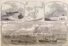
Twelve miles from the mainland is Ship Island. Iberville's fleet anchored here in 1699. The British used it as a base in 1815. Federals occupied Fort in Civil War.
Last updated: 4/3/2011 14:59
| StoppingPoints.com Editorial on Ship Island: | | Ship Island is the collective name for two barrier islands off the Gulf Coast of Mississippi, part of Gulf Islands National Seashore: East Ship Island and West Ship Island. Hurricane Camille split the once single island into 2 separate islands in 1969. |
|
|
|
Related Themes: C.S.A., Confederate States of America, Confederacy
Explore other
Mississippi Civil War Historical Markers.
|
| |
|
|
Image Gallery
|
|
|
Ship Island Historical Marker Location Map, Gulfport, Mississippi
|
|
|