| |
|
|
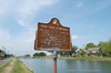
The Old Portage
Moss and Bell, New Orleans,
LA,
USA
Latitude & Longitude:
29° 58' 42.3264",
-90° 5' 16.8576"
|
|

Louisiana State
Historical Marker |
| |
| |
| |
|
|
Short trail from Lake Ponchartrain to River shown by Indians to Iberville and Bienville, 1699. Winding trail used by early travelers to city. From Bayou St. John it led to N. Broad, Bayou Roads, Vieux Carre to Mississippi at site between Dumaine and Gov. Nicholls Sts.
Last updated: 4/9/2016 20:07:26 |
|
|
|
| |
|
|
Image Gallery
|
|
|
The Old Portage Historical Marker Location Map, New Orleans, Louisiana
|
|
|